Wetland Monitoring
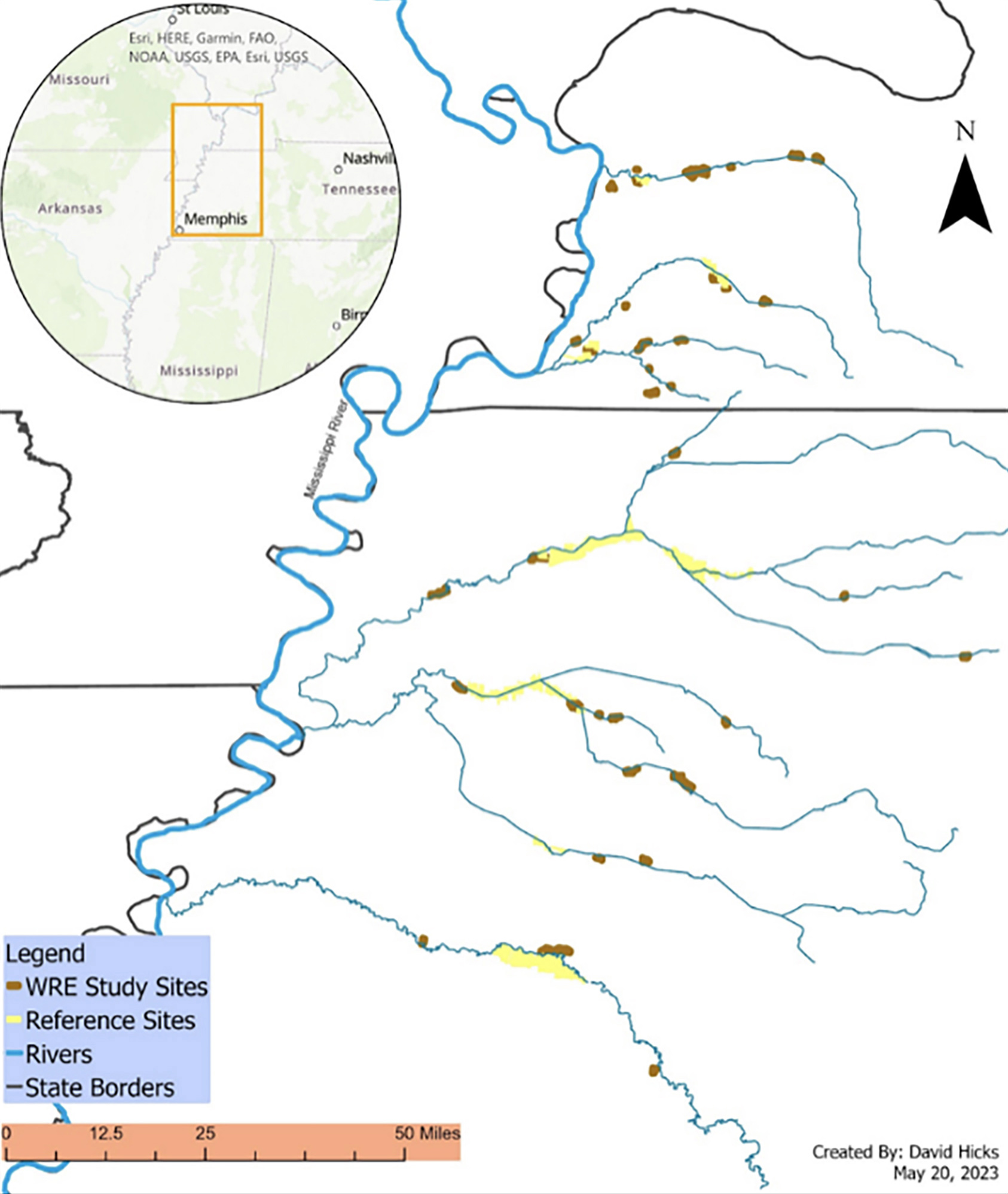
Location of Wetland Reserve Easements (n=35) and reference forest (n=10) study sites sampled in western Kentucky and Tennessee to assess forest composition and tree planting survival. Reference sites were located on state Wildlife Management Areas, a Public Hunting Area, and a National Wildlife Refuge. A subset of study sites was used in each of the overall project objectives. Map credit: David Hicks
Many years ago, western Kentucky wetlands formed an intact floodplain along the Mississippi and Ohio rivers. When this part of Kentucky was settled and cleared for fertile farmland and development, 80% of historic wetlands and their associated benefits were lost. Trees were cut down. Ditches and levees were installed. Streams were straightened, deepened and widened. This resulted in water running off the land quickly, taking pollution and sediment along with it.
Since 2011, TNC has worked with the U.S. Department of Agriculture Natural Resources Conservation Service (NRCS) to promote and implement a federal wetland conservation and restoration program that has enrolled more than 19,000 acres in an eight-county area in western Kentucky. Wetland restoration involves the use of voluntary programs to take frequently flooded land out of production, re-plant trees and change the way the water moves to restore natural wetland systems. Restoring hydrology may include plugging ditches that were previously installed to drain the land. Occasionally a water control structure is installed. In either case, the result is that water stays on the land longer. When the land is capable of absorbing and holding water longer, it can remove nutrient pollution, which leads to improved water quality in local streams, the Mississippi River and the Gulf of Mexico.
Photo credit: Mike Wilkinson
In 2018, a six-year, $4.36 million study was launched to monitor the effects of wetland restoration on wildlife, vegetation, soil and water-quality. The NRCS and TNC partnered to work with researchers from Murray State University, Tennessee Tech University, Middle Tennessee State University, the University of Missouri and the United States Geological Survey. This wetland restoration monitoring project provides valuable information that conservationists around the world can use to make their own projects more successful. Clarifying the effects of restoration will help conservation groups improve restoration practices and may help secure funding for future projects. We have learned that when these lands are restored, they do great things. They sequester nutrients and clean our water better than places that are not restored. The amount of native wildlife that are using these areas is phenomenal.
These web pages serve as a repository for all publications that have and will come out of the project. A list and links to publications and manuscripts from each lab’s monitoring are found in the sidebar to the right. What we’re really trying to accomplish here is a broader body of scientific knowledge and on-the-ground implementation across the entire Mississippi Basin. This project has already made huge contributions to our knowledge and will soon be driving changes in how we approach restoration.
Photo credit: Alen Baumann
The Natural Resources Conservation Service (NRCS), formerly known as the Soil Conservation Service, is an agency of the United States Department of Agriculture that provides technical assistance to farmers and other private landowners and managers. Through the Agricultural Conservation Easement Program’s Wetland Reserve Easements (WRE), the NRCS works with landowners to voluntarily enroll and restore wetlands and associated habitats on private and tribal lands into easements and contracts. These easements provide habitat for migratory waterfowl and other wetland dependent wildlife, including threatened and endangered species; improve water quality by filtering sediments and chemicals; reduce flooding; recharge groundwater; protect biological diversity; provide resilience to climate change; and provide opportunities for educational, scientific and limited recreational activities.
TNC works in all 50 states and in more than 70 countries. When TNC in Kentucky restores wetlands in the western part of the state, namely through a Wetland Reserve Enhancement Partnership with the NRCS, we are not working alone. TNC Business Units from 18 states are working together on the Mississippi River Basin Project, an initiative to reduce nutrient pollution going into the river, helping to dramatically reduce the size of the dead zone in the Gulf of Mexico.
TNC is increasingly working across borders to expand our impact. This is particularly true for TNC in Kentucky and Tennessee, which now share several staff members to maximize our impact on wetland restoration work, agriculture, prescribed fire and more.
Support Kentucky Nature
Help us restore wetlands and ensure a future in which people and nature can thrive.
Partners
Professor Justin Murdock of Tennessee Tech University pulled thousands of soil samples from wetland restoration sites for laboratory analysis to study nutrient retention and how the soils filtered water under flood conditions.
Dr. Michael Flinn of Murray State University monitored and quantified a suite of biological responses to wetland restoration. Factors included hydrology, sediment, surface water nutrients (nitrogen), vegetation, freshwater invertebrates, fish, herpetofauna, birds and bats.
Dr. Lisa Webb and Dr. Kristen Veum of the University of Missouri evaluated biotic responses to restoration over time by assessing soil microbial, physical and chemical properties, vegetation, macroinvertebrate, bird, and amphibian communities within 36 selected easements.
Dr. Donald Walker is leading research.
Photo credits this page ~ Main image: Kate Redmond; second image: Joanne Kline.