Wetlands By Design
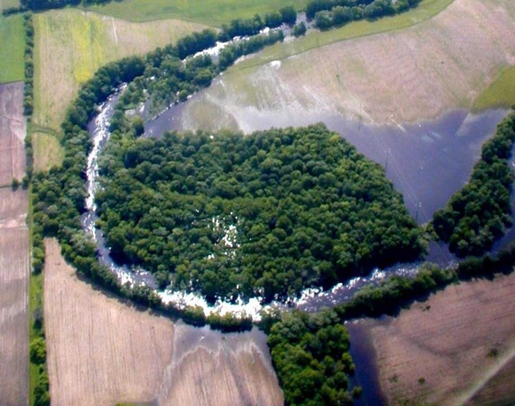
Floodplain forested wetlands, such as this one along the Milwaukee River, help purify water and reduce downstream flooding risks during storms. The flooded portions of adjacent fields, pihttps://freshwaternetwork.org/wp-admin/post.php?post=337&action=edit#ctured, are now being allowed to revert to natural wetland habitat, increasing the ability of this wetland to abate floods. Photo credit: Joanne Kline
More than half the wetlands once found in Wisconsin are gone. They were filled in or drained to grow crops and build cities and roads. With the loss of our wetlands went the many services they provide.
Wetlands can improve water quality, reduce flood impacts, help streams flow, provide habitat, and offer many other services. But not all wetlands provide the same services to the same degree.
The Nature Conservancy and the Wisconsin Department of Natural Resources have created an online tool to help Wisconsin citizens find the best sites to restore and protect—and the most promising watersheds to work in.
- Wetlands by Design: A Watershed Approach – a full report with overview, methods, and further guidance for protecting and restoring wetlands and the services they provide
- Wetlands and Watersheds Explorer – a free online mapping tool
- How to use the Explorer – an on-line demonstration
- Introduction and how to access the Explorer
- How to find a new site to protect or restore (minute 2:41)
- Watershed ranks (minute 3:36)
- Site ranks (minute 6:37)
- Helpful features: Changing basemaps & transparency sliders (minute 9:25)
- Wetland wildlife data (minute 11:12)
- Helpful feature: Optimizing view with transparency sliders (minute 12:20)
- Helpful features: Sharing and printing maps; downloading data (minute 12:54)
- Helpful features: Measuring and drawing on-screen (minute 14:35)
- How to evaluate a known site (minute 15:57)
- Helpful features: Section explanations, info buttons, assessment methods (minute 19:59)
Who is the tool designed for?
| Potential Explorer Users | Potential Applications |
|---|---|
| Local Governments | Development of watershed plans for water quality, e.g. 9 Key Element Plans; siting of natural infrastructure projects |
| Land Trusts | Strategic conservation planning; prioritizing projects; grant proposals; wetland education & outreach |
| Compensatory Mitigation Project Sponsors/Wetland Regulators | Identify and analyze potential restoration sites; guide project selection; support mitigation goals and improve outcomes |
| County Planners/Regional Planning Commissions | Aid in developing local and regional comprehensive plans; parks and open space plans; flood control and water quality improvements |
| Private Businesses | Wetland restoration as one component of meeting regulatory requirements, e.g. water quality trading and Adaptive Management programs |
| Wetland Consultants | Wetland restoration planning and design |
| Watershed Planners | Watershed assessments, water quality planning |
| Nutrient Management Specialists | Nutrient management planning |
| Wildlife/Other Resources Managers | Prioritize projects; identify and analyze sites; wetland restoration planning and design |
| Agricultural Producers | Nutrient management planning; habitat improvement |
| Lake Associations | Lake management plans; shoreline protection; water quality improvement; education and outreach |
| Universities/University Extensions | Wetland research; education and outreach; economic valuation of wetland ecosystem services |
How can I use it?
- You can use the tool to look for a site in a watershed that can provide flood abatement, water purification and other beneficial services.
- If you already have a site, you can use the tool to determine what services it is likely to provide and how that matches with the need for wetland services within a watershed.
Can you give me some examples?
If a community is experiencing increased flooding, then county planners might use the Explorer to look upstream in the watershed and determine where the best places are to protect and restore wetlands that will store water and help with flood control.
The Explorer can also be used to help secure funding for conservation of known sites. Land trusts seeking to protect a wetland can use the Explorer to describe the importance of the site for people and wildlife. Similarly, applicants seeking wetland mitigation funds can describe how restoration of a wetland can contribute to watershed goals.
Who do I contact if I have questions about the report or the Explorer tool?
Contact Nick Miller at The Nature Conservancy in Wisconsin at nmiller@tnc.org.
This project was made possible through funding from Region 5 of the U.S. Environmental Protection Agency and through generous donations from supporters of The Nature Conservancy.
Photo credits this page ~ Main image: Kate Redmond; second image: Joanne Kline.